Changes to North Saanich OCP Land Designations
| Resource | Link |
|---|---|
| Current OCP Bylaw: | https://northsaanich.ca/your-community/official-community-plan/ |
| Current OCP Land Designation Map: | Current OCP Land Designation Map: |
| Draft OCP Bylaw: | https://northsaanich.civicweb.net/document/123959/Staff Report No. PCS-25-006 Appendix A - OCP DRAFT.pdf |
| Draft OCP Land Designation Map: | https://northsaanich.civicweb.net/document/123961/Staff Report No. PCS-25-006 Appendix A - OCP DRAFT.pdf |
| OCP Project on ConnectNorthSaanich: | https://www.connectnorthsaanich.ca/2024ocp |
| Radio Sidney “Status of the North Saanich OCP” (Jan 2025): | https://news.radiosidney.ca/status-of-north-saanich-official-community-planning |
Essay Commentary
April 22nd Deadline for Input on the First Draft of North Saanich’s OCP
The first “complete” draft of North Saanich’s Official Community Plan (OCP) Bylaw was presented at the March 24th Council meeting and is now open for public input until April 22nd. The Province’s Bill-44 requires that North Saanich adopt a new OCP and Zoning Bylaw by December 31st 2025 which provide sufficient density to meet the 20-year housing supply. The 20-year supply target in NS’s Interim Housing Needs Report is an additional 2493 new units. What’s changed in the new OCP?
This article examines the proposed changes in land use designations and housing density in the draft OCP Bylaw. This is a preliminary analysis. Some sections of the OCP (e.g., definitions, map schedules and DPA maps) were still being worked and have not yet been released.
The draft OCP Bylaw states that the land designations satisfy the 20-year supply by providing potential for 2602 new residential units. The changes and additional density focus on a “transit-oriented” area around the McTavish roundabout and a corridor 400m-wide along East Saanich Road.
Two new residential land designations have been created with higher housing density: Attached Ground-Oriented Residential and Neighbourhood Residential; and Multi-family Affordable Housing Residential has been modified to become just Multi-family Residential with higher housing density. The existing General Residential designation received minor updates and continues to apply to the single-family parcels outside of this transit-oriented area.
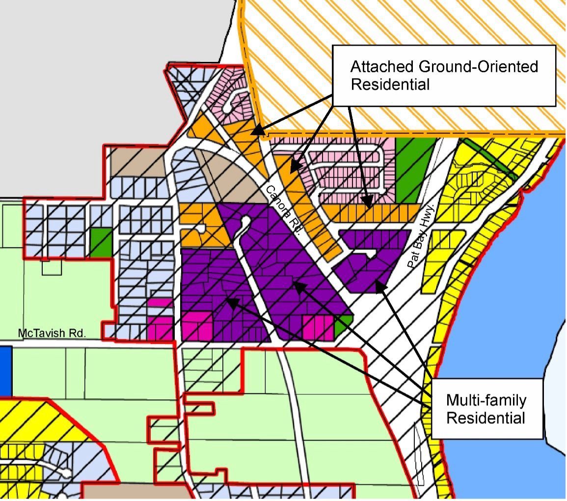
The new Neighbourhood Residential designation is similar to the existing General Residential designation except it allows both a secondary suite and an accessory dwelling, while the General Residential designation allows one additional unit, either a secondary suite or accessory dwelling, and only “in appropriate circumstances”. The majority of parcels becoming Neighbourhood Residential are being up-zoned from General Residential, although some are currently designated Multi-family Affordable Housing Residential.
Parcels on the north side of Bakerview Pl., as well as some fronting Canora Rd., East Saanich Rd. and Burrows Lane have been given the new Attached Ground-Oriented Residential designation which permits “Attached Ground-Oriented Residential” development (e.g., townhouses) with a maximum Floor Space Ratio (FSR) of 0.6 to a maximum of 15 units/acre, up to 3 storeys. Secondary suites are permitted to meet affordable, special needs or seniors housing needs.
Multi-family Residential replaces the current Multi-family Affordable Housing Residential designation without a requirement for affordable housing. Density is also increased from an average gross density of 16 units/acre to 40 units/acre with a maximum 0.8 FSR. An additional 4th storey may be allowed for seniors housing.
For comparison, the base FSR for townhouses and apartments in Sidney’s RM5 and RM6 range from 0.75 to 0.9 with bonus density from 1.3 to 1.75 FSR at a maximum 3-storeys.
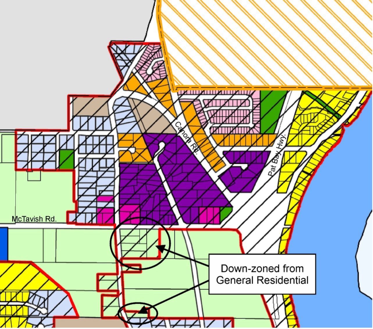
Residents and property owners should look at the draft OCP Land Designation Map carefully, because the designations for some parcels have been down-zoned (allowing less density). For example, some properties along East Saanich and McTavish Roads have been down-zoned from General Residential to Agriculture (see below).
These are only some of the significant changes in the draft OCP Bylaw. However, many sections of the OCP have not yet been released. And, details of how the calculation of number of housing units based on land designations was done are not available.
The OCP Project timeline anticipates completing the second draft of the OCP Bylaw in May with a Public Hearing and adoption of the OCP Bylaw in June. A survey is currently seeking input on the draft OCP on the ConnectNorthSaanich.ca website. A virtual webinar is planned for noon to 1:30pm April 10th and in-person presentations 4:00pm to 6:00pm on April 15th at Saanich Peninsula Presbyterian Church and 6:00pm to 8:00pm on April 17th at McTavish Academy of Art.
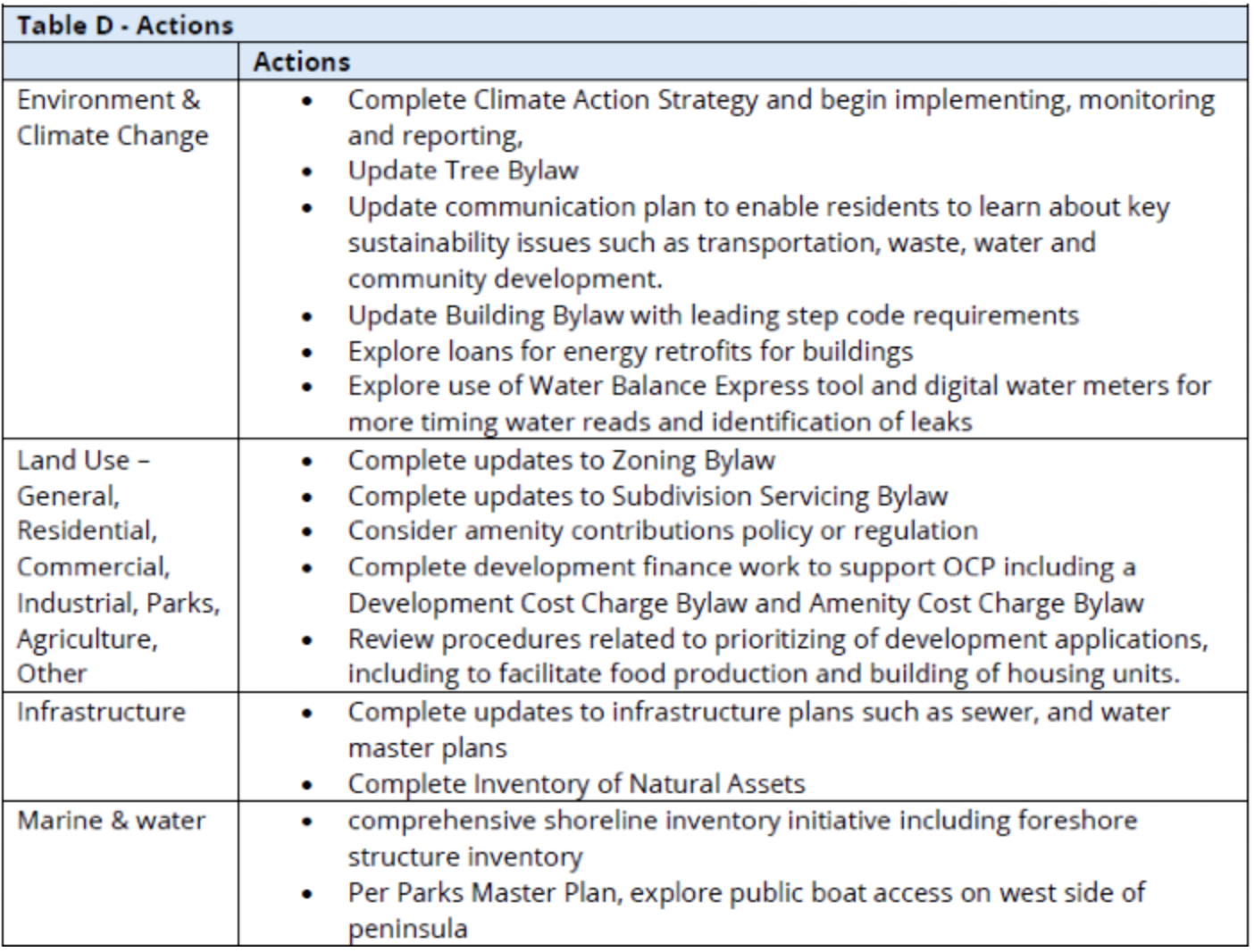
While the land use designations and housing density are the parts of the OCP which are the focus of controversy, the draft OCP includes other changes that are significant. For example, Table D (below) in the Implementation section lists priority actions to be completed by future Councils.
The draft OCP Bylaw is a major update to North Saanich’s Official Community Plan. There are eleven (11) weeks remaining for public dialogue and revisions to the draft OCP before it goes to Public Hearing.
We invite you to comment below. You do not have to sign in. When you start typing your name, a small check box will appear below the terms and conditions. Checking the box will allow you comment as a guest requiring only your name and email address. Your email address remains confidential.


